
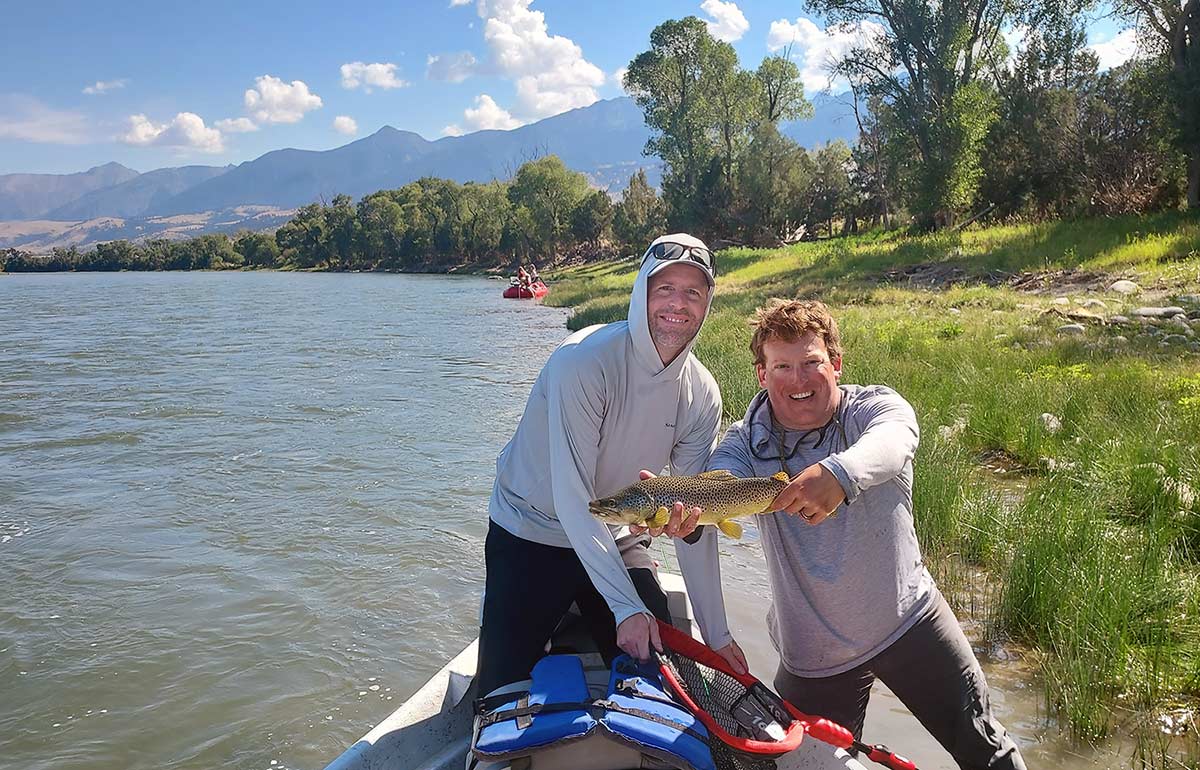
The Yellowstone River is the most famous and most fished river near Livingston, and our home water. It flows right through Livingston, and there are certain times of year (late April through early May and late September, especially) when the “town section” might even be our favorite stretch of the river. Use this Yellowstone River fishing guide to plan your DIY trip, or learn about a guided trip instead.
Unlike most waters near Livingston, some portion of the Yellowstone fishes well almost the entire year, with the main exception being the torrential May–June spring snowmelt, and the river has no closed season.
While it’s not a great wade-fishing river due to deep water and fast current, plus limited access, some wade-fishing on the Yellowstone is always available. The best water to wade is found in the first 17 miles downstream of Gardiner, where the banks are often rocky rather than brushy (which makes travel easier) and where there’s an abundance of public land, which makes it much easier to cover lots of water without fear of trespassing by accidentally climbing above the high water mark.
The Yellowstone in Montana is one of the West’s premier float rivers. With about 150 miles of blue-ribbon trout water extending from Gardiner almost to Billings (plus great bass water downstream of Billings), the Yellowstone offers a huge array of possible floats and a variety of experiences as far as river character, target species and tactics, scenery, and so on.
- Learn about our guided Float Trips on the Yellowstone River, available March through early November. We also run Walk & Wade trips on the Yellowstone, mostly in late winter, early spring, and late fall.
- Corwin Springs Streamflow Graph: Fishable flows are generally 10,000cfs and lower for float-fishing. The lower the better for wade-fishing. Sudden spikes mean muddy water.
- Montana Whitewater Gardiner Webcam: This cam is located at the Montana Whitewater office in Gardiner. Check this camera to know if muddy water is on the way to Livingston.
- Pine Creek Webcam: This cam is just south of Livingston. Mud here means mud will hit Livingston in a couple hours, at most.
Yellowstone River Fishing Guide – River Description
While it changes hugely in character over its course, one word describes the Yellowstone throughout its “trouty” run in Montana: big. This is one of the largest float rivers in the West in volume. Fishable flows near Gardiner range from around 1000 cubic feet per second in the dead of winter on up to close to 10,000cfs immediately after the spring melt starts to recede in early July. The river is also very wide in many areas, particularly in Paradise Valley and east of Livingston. It’s seldom particularly deep except in Yankee Jim Canyon, but it’s impossible to wade across even in the dead of winter except in a handful of locations. Much of the fishing is therefore done along the banks, both in terms of where wade-anglers stand and where boat anglers cast. When the water’s high, the trout are all a foot from the bank.
Because it is so long and flows through varied topography, going into more detail describing the Yellowstone as a whole doesn’t make much sense. Instead check out the “Sections of the Yellowstone” portion of this page below. Details on access for each section are also provided there.
Access to the Yellowstone is very good over most of its trouty length, which isn’t surprising considering the river’s fame and quality. Wade access is not as good as float access.
Paradise Valley south of Livingston is a favorite stretch for many anglers.
Yellowstone River – Directions & Access
The Yellowstone is followed by US-89 between Gardiner and Livingston and by I-90 between Livingston and Laurel, where the Clark’s Fork of the Yellowstone enters and warms the Yellowstone enough that it ceases being a quality trout river. As such, it’s very easy to access. Some boat ramps are too rough for anything except high-clearance 4WD vehicles, but the access roads and parking areas for all public access points are suitable for any passenger car.
Access points suitable for boats are generally found about every five miles between Gardiner and just east of Livingston. Downstream from there, it’s closer to every 10 miles. Some of these have good wading access, some almost none. Long stretches of public bank providing good wade access are much more extensive near Gardiner, as described in the “Sections” portion of this page below.
Here are links to public lands maps on the Yellowstone:
- Montana FWP Fishing Access Sites on the Yellowstone:
- US Forest Service Map: This map is focused near Gardiner. Everything in green is USFS and accessible to the public. Also note that the west bank of the river is inside YNP between Gardiner and Reese Creek four miles downstream. The river is in Montana and requires MT licenses, but the bank is entirely public and available for walk/wade access.
There is also an excellent public access at Carbella on BLM land, about 17mi from Gardiner. Other accesses are generally on highway dept right of ways or otherwise somewhat ad-hoc; a paper map or an app like onXmaps is really required to know how to find these, if you aren’t already familiar.
Yellowstone River – Angling
The Yellowstone River has a lot to offer most anglers. About the only exceptions are anglers who prefer small water, which the Yellowstone most distinctly is not. Depending on tactics, time of year, and section, it can produce both big trout and lots of them. At times in the summer, it can do both on the same day, though of course you have to hit it just right for that to happen.
Fish Populations
- Yellowstone Cutthroat: Native cutthroats comprise 1/3 to 1/2 the trout population upstream from Carbella Access and fade downstream. East of Livingston they become rare. Cutthroat numbers and size are highest from late summer through the onset of spring runoff. In early summer they tend to be up in tributaries spawning (let them do it in peace). Average cutthroats run 8–16 inches. Some larger ones are possible, but anything over 20 inches is probably hybridized with a rainbow.
- Rainbow and Rainbow x Cutthroat Hybrid (Cutt-Bow): Rainbows are common throughout the Yellowstone’s run in Montana and are the most common trout downtream from Point of Rocks Access 20mi north of Gardiner. They average 8–18 inches depending on the section and season. The largest rainbows are caught in late winter and spring on average, which is about the only time fish over 20 inches aren’t anything but a huge surprise. Even so, most of the larger rainbows are actually hybridized at least slightly with cutthroats. The rainbows run larger on average downstream of Point of Rocks than above.
- Brown: Browns are common throughout the Yellowstone’s run in Montana, though you sometimes don’t see them when fishing dry flies on bright, sunny days. They average 8–18 inches and are the only trout species in the Yellowstone for which a 20-incher is big but not huge. When specifically trying for bigger browns (generally with streamers), most run 16–20 inches. Fish in the 24-inch class are by no means common but aren’t out of the realm of possibility, particularly east of Livingston, and in an average year I have clients hook some bigger ones.
- Mountain Whitefish: By biomass, there are actually more whitefish in the Yellowstone upstream from Livingston than there are trout. They thin out downstream but are still present all the way to Columbus and beyond. The heaviest populations are between Corwin Springs and Yankee Jim Canyon, particularly in the fall when it’s basically impossible to nymph-fish this section without picking up whitefish at a 10:1 ratio to trout. Because of their abundance, the whitefish are kind to beginners. They average 10–14 inches but can reach 22 inches, particularly in Paradise Valley.
- Other Fish: A couple species of suckers, goldeye, carp, and smallmouth bass are all present. Except the suckers, they are far more common east of Livingston, particularly near Columbus. They are seldom caught upstream from Big Timber. All smallmouth bass must be killed upstream from the Springdale Access about 20mi east of Livingston.
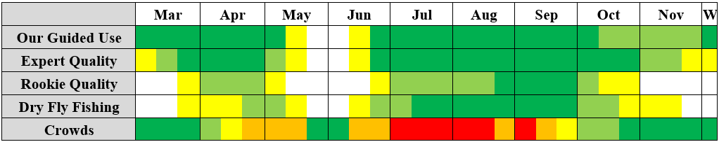
Yellowstone River Fishing Season – When It’s Open & When It’s Good
The Yellowstone River in Montana is open to fishing year-round. Late winter and early spring fishing from mid-March through April or early May is inconsistent but can be highly productive for larger-than-average trout with few other anglers around. The spring runoff—which always resembles a flood, with trees and so forth carried along and the river way up in the bushes—in May and June puts the river completely out of play for a month to six weeks except for a day at a time if we’re blessed with an extended dry cold snap. The runoff usually begins in earnest in the second week of May.
The river drops into barely-fishable shape between June 15 and July 10, with the last week of June or first few days of July most common. Fishing then remains consistent through early October. Big fish opportunities continue until the middle of November, though numbers usually drop off. Winter fishing is limited to ice-free areas, of which the best is right through Gardiner. The influence of the hot spring-fed Gardner River keeps the Yellowstone right through town warmer than anywhere else. Good midge fishing is possible even in January if the weather is calm and near-freezing.
Here are five highlights of the season, arranged according to the calendar.
- Winter Midge-Fishing Near Gardiner: While it’s only good for a couple hours in the afternoons, and doesn’t happen every day, the midging near Gardiner can be very productive. It’s best in February. Fish a WD-40 behind a Lightning Bug or similar nymph until you start seeing rising trout. Then fish a Griffith’s Gnat or similar simple midge behind a Purple Hazy Cripple or similar small attractor dry that you can see. Some BWO also hatch with the midges.
- Spring Nymph & Streamer Fishing: This fishing is good anywhere on the Yellowstone, but is strongest near tributaries. Bump the bottom with a stonefly nymph or large attractor nymph (Girdle Bug) trailing an egg or smaller attractor nymph, or swing streamers. This fishing produces the largest rainbow trout of the season on average, and can also turn out some big post-spawn browns. It’s best in March and early April, but continues until the runoff hits.
- Summer Streamer Fishing: It shocks many visitors to learn that more big browns are caught in July and early August than at other times. Most of these fish are caught on streamers or a nymph behind a streamer. Fish a sculpin, Zonker, or Woolly Bugger under an indicator. Mend upstream repeatedly to twitch these flies or allow them to swing on a tight line. This is the best option for novice anglers to catch large fish. This fishing is best in Paradise Valley and east of Livingston.
- Summer Dry-Dropper Fishing: While some dry-dropper fishing is possible in spring and summer dry-dropper fishing begins as soon as runoff declines, it’s best from late July through Labor Day assuming normal water conditions. This fishing begins with stonefly-type or caddis-type attractor dries (Chubby Chernobyl or Coachman Trude, respectively) with caddis pupae or large attractor nymphs (Prince, small Girdle Bug, caddis-style Euro Nymphs) on a long dropper. In August it transitions to dedicated grasshoppers (large or small) with mayfly and small attractor nymphs on the dropper. This technique can at time produce lots of trout as well as some big ones, and is good on the entire river.
- Fall Dry Fly Fishing: Heavy hatches of BWO and sometimes Tan Drakes combined with sparse hatches of other mayflies, midges, and remaining ants and grasshoppers makes for excellent dry fly fishing in September and early October. Often experienced anglers can fish two dry flies (a hopper or large mayfly-style attractor with a small mayfly-style attractor or hatch-matching mayfly on the dropper from 10:30AM until 5:00PM, without any nymph being necessary. This fishing is best in the 20mi below Gardiner and through Livingston and less consistent elsewhere. Bright, sunny skies and shallow water in Paradise Valley can be particularly difficult for those eager for this fishing.
Yellowstone River Fishing Tactics
Most of the top tactics on the Yellowstone can be gleaned from the above list, but here are some more details.
A good rule of thumb on the Yellowstone is that the colder and/or lower the water and the brighter the skies, the more likely you’ll need to fish subsurface. This is especially true in the widest, shallowest stretches of river like the section immediately upstream from Yankee Jim Canyon and in large swathes of upper and middle Paradise Valley.
In practical terms, you should expect to fish nymphs or slowly-dragged streamers under an indicator from November through mid-April unless you see rising trout. Late April can be good with stripped streamers (more aggressive techniques) but is likewise subsurface-only until you see rising trout. October can produce on stripped streamers and sometimes on blind-fished dries.
When nymphing, small nymphs are best only in the dead of winter. Otherwise, it’s usually best to fish a streamer or large attractor or stonefly nymph with a smaller nymph on the dropper, to give the trout two very different mouthfuls.
From the tail end of runoff in late June or early July through September, it’s almost always possible to catch some fish on dry flies (and especially dry-dropper combinations). The best dry fly fishing runs from late July through September 20 in average years. In low-water years it may be best in July and September, with August harder. The average size of productive dry flies declines through the summer and early fall. Whereas a #8 Chubby Chernobyl supporting a #10–12 nymph is a great combo in July, by late September you’re more likely to fish a #14 mayfly-style attractor dry (Royal Wulff, etc.) with a #16 on the dropper. Caddis hatches (including small caddis-style attractors like Trudes) are the main exception early in the summer, while the fish will still crash a big hopper from time to time in September.
Finding Yellowstone River Trout
Through most of the year on most stretches, it’s easy to figure out where to find Yellowstone River fish. A good rule of thumb here is that the fish will be in or at least immediately adjacent to fast water the warmer the water gets. The brighter the skies, the more they will be choppier and/or deeper water.
From November through mid-April, they’ll be in the walking-speed runs from four to six feet deep, especially those adjacent to deep, dead-slow pools or to warm water sources like hot springs or the mouths of spring creeks. Thereafter they begin moving into slightly faster runs as the water warms, and may be found along steep, rocky banks provided there’s eddies to concentrate food and slow the current.
Immediately following the spring melt, trout can often be found within inches of steep, rocky banks, no matter the current speed. They’ll stay in these areas until water temps begin to drop in late August or September. Just look for the closest current seam to the rocks that drops off into green depths, no matter if this seam is six inches from the shore (July) or 6 feet from the shore (September). These areas are most common in the 17mi north of Gardiner, but there are patches of this structure throughout the Yellowstone’s “trouty” water.
Where the banks aren’t as steep, the fish may be on the bottom several feet away from the bank (or bushes) even early in the season. These seams continue to move offshore as the season progresses. In shallow sections of river, the trout may be in the middle of the river as early as early August, hiding behind boulders and other depressions. Such areas are most common in Paradise Valley and some stretches east of Livingston.
In areas with long pools separated by riffles, especially where island complexes are common, by early August the fish will usually sit just below the riffles and on the seams below islands. Such areas also have choppy cobble-bottomed flats that the trout like. These areas are most common in lower Paradise Valley and east of Livingston.
Low water periods on broad, shallow stretches of river make for hard times finding trout, especially if you’re on foot. The trout will be in the slightest depressions with slight current breaks. If the river is three feet deep all the way across, with a cobble bottom, a single boulder with a drop-off to four feet will have five fish in it. That said, these conditions make for difficult fishing. This is one reason why I avoid large areas of Paradise Valley from September through April: the fish are so scattered in small pockets amid the shallow water that there are large dead zones. Thankfully there are few areas like this near Gardiner, with the “grassland” stretching a mile upstream from Yankee Jim Canyon the main example.
It is very uncommon for feeding trout to be found in totally homogeneous, slow-moving pools, especially where the bottom is composed of sand, silt, or gravel rather than mixed rock and boulders. In general, trout crave variety even in the dead of winter: variety of current speeds, variety of depths, variety of bottom substrate. In areas without any variety, you’re likely to find whitefish or perhaps no fish at all.
Insect Hatches & Other Prey
The following table provides info on important insect hatches for the Yellowstone in Montana. Note that some sections of river see better hatches of specific insects than others, since the Yellowstone’s prey base changes a lot over its 150 miles of fishable water in Montana. This is noted in the “Sections” portion of this page below.
For information on insects and other food sources noted here, visit the Trout Prey page.
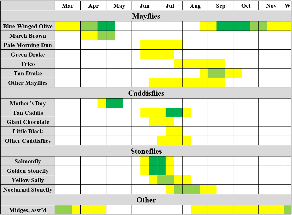
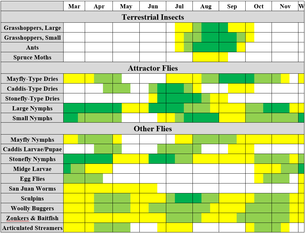
The next table provides info on other important trout foods and flies, ranging from baitfish to attractor dry flies. Again, some food items are more important on some stretches than others. For info on fly patterns and types of flies noted in this table, visit the Fly Suggestions page.
Top 10 Flies for The Yellowstone River
These flies are in no particular order. You ought to carry them all year-round, plus imitations of the important prey species present when you’re here.
- Tan/Black Girdle Bug, #8
- Delektable Pheasant Tail, #16
- Purple Hazy Cripple, #16–18
- Copper Hazy Cripple, #16–18
- Olive Zonker, #6
- Olive McCune’s Sculpin, #6
- Black Woolly Bugger, #6
- Beadhead Prince, #12 and #16
- Red Copper John or CDC Copper John, #16–18
- 20-Incher, #10
The flies above don’t tell the whole story. For much of the season, other dry flies can be extremely effective and we can often get by with fishing nothing else. Chubby Chernobyls, various caddis, grasshoppers, and ants are all key flies, but each of these might only work for a month or so. The flies above might work all season.
Sections of the Yellowstone River in Montana
The Yellowstone in Montana can be roughly divided into four sections from a trout fishing perspective. Each section provides somewhat different experiences and scenery, holds a different population mix of trout as far as species and size vs. numbers, requires somewhat different tactics, and fishes better at certain times of year and flows.
In general, the river closer to Gardiner is better for numbers of trout, cutthroat trout, and dry fly fishing. The further downriver you go, the more the population shifts towards fewer but larger trout, more rainbows and browns, and subsurface fishing often being required. Stretches near Gardiner are best in both the dead of winter and late summer, while stretches lower down may ice over in winter and may get too low and warm on late July and August afternoons, though this depends on weather.
For more details, read on.
“The Upper River” – Gardiner to Carbella
The “Upper Yellowstone” stretches from the Yellowstone National Park boundary at the mouth of the Gardner River (upstream of which YNP regulations apply, see the appropriate page) downstream about 17.5 miles to the BLM’s Carbella campground and fishing access at the upstream end of Paradise Valley.
For what it’s worth, this is the stretch where Walter got his start as a Yellowstone River fishing guide.
This stretch of river is predominately fast and turbulent, particularly from Gardiner to La Duke Hot Springs about six miles north of Gardiner and from Yankee Jim Fishing Access at Hwy 89’s 13 mile marker down to Carbella. This is Yankee Jim Canyon, the heaviest whitewater on the Yellowstone outside of Yellowstone National Park. There are at least occasional class-II+ rapids (occasionally pushing class-IV at high water) everywhere between Gardiner and Carbella except from about mile marker 9 to 13. These rapids are almost continuous from Gardiner to McConnell Access 3 miles north of Gardiner and in the upper 2/3 of Yankee Jim Canyon. Rocky banks dominate most of this stretch, with the long meadow from roughly mm 11 to 13 the main exception. Even the gentle areas usually have rocky banks, while the fast and turbulent sections are all boulders.
This stretch holds far more cutthroat trout than other stretches in Montana thanks to many productive spawning tributary creeks (cutthroats require quality tributaries for spawning purposes). The population is rounded out by rainbows and slightly lower populations of browns. There are also vast numbers of whitefish on this stretch, particularly between Corwin Springs about 8mi north of Gardiner and the top of Yankee Jim Canyon. Trout of all species are more prone to taking dry flies on this stretch than anywhere else, but the average fish size is lower except in spring, when larger rainbows run upstream preparing to spawn, and in fall, when browns do the same. The average fish during the core summer season run 10–14 inches, with fish to 18 inches not uncommon but also plenty of fingerlings.
The Upper River is less beginner-friendly than most other sections of the Yellowstone, particularly between Gardiner and Corwin Springs and in Yankee Jim Canyon. This is due to the fast and turbulent nature of the water, which demands quick, accurate casts. It’s better for intermediate anglers than many other sections, however, since the high overall trout populations and their eagerness to rise mean intermediates can usually catch lots of fish.
The Upper Yellowstone is consistent throughout the year except during the May–June spring melt. Peak season begins with the Salmonfly and Golden Stonefly hatches (along with various caddis, mayflies, etc.) immediately following the spring melt, usually in the last week of June or first week of July. The remainder of July is usually a dry-dropper game, with large stonefly nymphs under big Chubby Chernobyls often the best bets. Both flies match the occasional Nocturnal Stoneflies seen during the day, but the trout encounter at night.
August and early September see excellent fishing with terrestrial dry flies, especially small hoppers and ants, and can see scattered mayfly hatches (Tricos and odds and ends) which are usually not intense enough to require precise imitation—small mayfly-style attractor dries like my Purple Hazy Cripple are usually close enough.
Later in September and in October, Blue-winged Olive hatches can be intense at midday and in the afternoons, while there may also be Tan Drake (aka Hecuba) mayflies and some midges. Streamer fishing improves steadily in October, and both streamers and large stonefly nymphs and egg patterns turn big browns in lake October and early November.
Mid-November through February sees winter fishing conditions: fish with midges and stonefly and attractor nymphs in the slowest runs, particularly right through Gardiner where the geyser-heated Gardner River makes the water warmer than anywhere else on the Yellowstone at this time. Right through Gardiner is actually the best fishing on the entire Yellowstone in the dead of winter.
March and April sees rainbow trout moving upstream towards tributaries prior to spawning. Streamers and stonefly nymphs trailing attractor nymphs and eggs are productive at this time. Midge, BWO, and March Brown hatches are also possible, especially in the second half of April. Early May can bring an early onset to the spring runoff, but when the river is clear streamers and Mother’s Day caddis hatches can produce excellent fishing. The spring melt usually hits between May 5 and May 15 and shuts down fishing until the last week of June or first week of July except in drought years, when fishing can begin everywhere except Yankee Jim Canyon between June 15 and June 20.
From Queen of Waters to Yankee Jim is floatable when flows are under about 10,000cfs (assuming a skilled oarsman) as measured at the Corwin Springs stream gauge. I do not recommend floating between Gardiner and Queen of Waters or through Yankee Jim Canyon at flows over 6,000cfs. It’s worth fishing either afoot or from a boat whenever it’s clear. This usually happens between 10,000 and 8,000cfs.
Access to this stretch is excellent, with many official accesses plus lots of public land. Important accesses are as follows, beginning at the upstream end in Gardiner:
- Accesses in Gardiner: Right through Gardiner fishes very well and has abundant access. The first is via a walk-down access at the mouth of the Gardner River at the east end of Park (or Front) Street. Duck through the gap in the YNP boundary fence and walk down the obvious gravel road to the confluence of the Gardner and Yellowstone. Rafts may launch here, but there’s no way of launching a drift boat. This limits fishing traffic through Gardiner. Note that the mouth of the Gardner River is the YNP boundary line. The stretch of Yellowstone upstream from this point is discussed on the Yellowstone River – YNP page. The next access is the US-89 Bridge. Clamber down on either side of the bridge. The final access is on Old Yellowstone Trail (the gravel road that heads near the Park’s entrance arch). Stop at the first pullout north of Gardiner, take the trail to the first gully, then clamber down to the river to fish back to the bridge. Various businesses also have private access for their clients/customers/guests.
- YNP Accesses: The first four miles of river downstream from Gardiner is accessible via the west bank from a northern extension of Yellowstone Park that extends down to Reese Creek. The west bank of the river is public and you may walk anywhere. The best accesses are as follows: Railroad Trail: The trail beginning at the pullout noted above follows the old railroad grade for a couple miles. It is high above the river, but numerous game trails provide access for surefooted anglers. The trail reconnects with Old Yellowstone Trail near Steven’s Creek about 2mi downstream. Beyond this point, Old Yellowstone Trail is out of sight of the river across a sagebrush flat. The easiest remaining access is to park immediately south of Reese Creek (there’s a pullout), then follow Reese Creek a couple hundred yards down to the river.
- Queen of Waters/Gardiner Airport: This state access is the first feasible drift boat launch when the water is high, but it’s better for rafts and rough for anything. It is not usable by drift boats when flows get under 3500cfs. It’s an unsigned state access. Take US-89 north to the road adjacent to the south end of the Gardiner airfield. Turn here, then bear right around the south end of the runway to the first (steep) stub road. Take the switchbacks down the hill past the sewage treatment plant to the obvious turnaround. What you see is what you get as far as a boat ramp. This area offers good wade-fishing in early fall after the water has dropped.
- McConnell Access: Near the 3 mile marker on US-89. Easy sand boat launch and lots of parking. This is where most drift boats launch. Fish upstream on foot for less boat traffic.
- La Duke Hot Spring Area: A stretch of National Forest and highway department frontage extends from the large pullout south of La Duke Hot Spring down past the hot spring (on a near-vertical bank right under the highway), past the hot spring picnic area, and down past Brogan’s Landing FAS. This is over a mile of public bank. The fishing is very good, but the bank is generally very steep.
- Brogan’s Landing FAS: About 7mi north of Gardiner. This was formerly a good sand boat launch, but it was destroyed by the 2022 floods and is currently closed.
- Cinnabar and Corwin Spring Bridge: Cross the Corwin Springs Bridge about 8mi north of Gardiner. Park at the west side of the bridge and fish upstream or down, or turn south onto Old Yellowstone Trail and park at Cinnabar, the obvious Forest Service Access visible from the bridge. The bank south of the USFS access is public for a ways.
- Cutler Lake Area: Cutler Lake itself holds only fingerling perch, but the river east of Cutler all the way through Yankee Jim Canyon is now Forest Service property after a land swap. It’s a long, hard clamber down to the river from the Cutler area, but this gets you on a stretch that sees lots of float traffic but almost no wading traffic. To access this stretch as well as the west side of upper Yankee Jim Canyon, take Old Yellowstone Trail northward from the Corwin Springs Bridge.
- Slip & Slide FAS: About 12mi north of Gardiner on US-89, this is a small dirt pullout with a steep path down to the river. No boat launch.
- Yankee Jim Access: National Forest boat ramp (and to a lesser extent wade access). Dirt/gravel launch that can be tough right after runoff and may require 4WD at any time. This is the last drift boat takeout before Yankee Jim Canyon, which is not floatable with low-profile drift boats and is very hard even with high-side boats. Most float-fishing through the canyon is thus in whitewater rafts equipped with fishing frames.
- Yankee Jim Canyon: Yankee Jim Canyon is almost 4mi long, of which all of the east bank is public and over half the west bank is public. Access the west bank via Old Yellowstone Trail. Note that the road ends about 1/3 of the way down the canyon at a washout. The east bank is directly under US-89 for most of the canyon. Many pullouts provide access to the canyon proper. Crystal Cross Access adjacent to the washed-out Tom Miner Bridge and Carbella provide access to the bottom end of the Upper Yellowstone.
Upper and Middle Paradise Valley – Carbella to Pine Creek
Carbella BLM Access down to Pine Creek FAS comprises the upper and middle portions of Paradise Valley. This stretch is commonly regarded as the most scenic stretch of the Yellowstone River, and while it has a higher gradient than many areas east of Livingston, there are few actual rapids. Except for a series of island complexes between the 26-Mile (unofficial but public) Access and Emigrant Bridge about 32mi north of Gardiner and between Mallard’s Rest and Pine Creek in the bottom 3mi or so of this section, the river is usually a single broad and usually shallow channel. Great views of the mountains distract from the fishing. There are some rocky stretches of bank, particularly between the Mill Creek Road Bridge north of Emigrant and Mallard’s Rest FAS, but many areas are instead covered with willows and cottonwood, with their roots reaching almost into the river.
Floating is by far the best method of fishing this water. While there is some public wading access, the character of the river and the fact the best fishing occurs while the water is still a bit high (even in the bushes) makes for tough fishing in most spots if you’re limited to wading.
While it’s often rather swift, particularly from Mill Creek Bridge to Mallard’s Rest, there are very few actual rapids on this stretch of the Yellowstone. There’s one nasty one at a big bend in the river a couple miles upstream from Emigrant and one wave train at the bend upstream from Mill Creek Bridge, but otherwise this stretch is suitable for all sorts of watercraft including canoes and inner tubes. This leads to drastically higher recreational and fishing traffic than found on the Upper Yellowstone, particularly on the 4th of July and Labor Day weekends, when I will not guide here. Weekdays are far more manageable, though you should launch your boat early to avoid crowds, or fish just upstream from Emigrant or Pine Creek early in the day and near Carbella or Grey Owl accesses late in the day if you’re on foot.
Cutthroats are probably the most common trout from Carbella at about 18mi north of Gardiner downstream to the US-89 Bridge near the 20 mile marker, but their numbers drop off rapidly thereafter. Some days between Emigrant and Pine Creek we’ll see a handful of cutts, some days none. Rainbows and browns dominate between Point of Rocks and Pine Creek. Rainbows are far more numerous, but the browns get bigger. I have had clients land several fish in the 24″ class, while I’ve had clients hook but lose several in the 26–28″ range. The “bread and butter” browns run 15–22 inches. The rainbows and cutthroats average 12–18 inches, though if you’re fishing dry flies you can run into vast swarms of hand-size fish at times. There are also plenty of whitefish, some of which exceed 20 inches.
Because it’s somewhat homogeneous in many areas and does not require accurate casting (particularly when nymph fishing), this section is by far the best stretch of the Yellowstone for beginners and novices. When fishing a streamer and nymph under an indicator, beginners stand to catch lots of whitefish, a few small trout, and a couple big browns. Anglers with some experience can do well with similar tactics but more active presentations, while dry-dropper and some pure dry fly fishing can also be very good, both for numbers and larger fish. One of the 26+ inch monsters noted above ate a longtime client’s #6 Turck’s Tarantula dry fly.
This stretch is not as consistent as the Upper Yellowstone on a year-round basis, especially during the low water period from late August or September through April. This is due to the stretch’s extreme shallowness in spots. If fishing outside of July–August, the key is always finding the deepest runs. July–August fishing can involve pounding the banks as it usually does on the Upper Yellowstone, but even in August it’s often possible to find trout smack in the middle of the river, or at least off the first couple shelves 20+ feet from the bank. Very limited fishing is possible on this stretch in the winter, due mostly to ice and extreme shallow water. I usually ignore this whole run prior to late April or even early May, when the water comes up.
Highlights of the July–August peak season are the July nymph fishing, which is interspersed with sparse Salmonfly and Golden Stonefly hatches and some hatches of various caddis and mayflies. August sees excellent hopper-dropper fishing, with either a big hopper trailing a stonefly nymph (Nocturnal Stone imitation) or a smaller hopper trailing a smaller attractor nymph or ant/small attractor dry both producing, the former at higher water and the latter when things are getting low. September can see BWO and Drake Mackeral hatches, but nymphing the deepest runs is usually more productive. This trend continues through fall, though by October I seldom fish this stretch due to the shallow water and scattered fish.
This entire stretch is floatable as soon as it becomes clear enough to fish, which usually happens between 10,000 and 8,000cfs as measured at Corwin, though I have seen it happen in high-water years as high as 13,000. The easiest water to row at such high levels is unquestionably from Emigrant to Loch Leven (or Mallard’s Rest once it’s fixed). The best fishing always occurs when flows are higher than 2,000cfs. I seldom fish it when it’s lower than this. 3,000–5,000cfs is ideal, which is usually seen from mid-July through mid-August.
Access on this stretch is far better for boat anglers than waders, a trend which continues for the remainder of the Yellowstone’s run. Key accesses include the following, beginning at the upstream end:
- Carbella: The Carbella Campground and concrete boat launch is about 18mi north of Gardiner. Look for the electrical substation near the 17 mile mark. Turn west, then immediately turn right onto a signed road that says Carbella. Follow this road to its end, where there’s a large parking area and concrete boat launch. The wade-fishing upstream from the ramp can be great in the fall, though the campground crowds pound it during the summer.
- Point of Rocks: Point of Rocks has two parcels. The concrete boat launch is upstream from and immediately adjacent to the north end of the US-89 Bridge near the 20 mile marker. The downstream parcel is less than half a mile north and is foot-access only.
- Rest Area: The Hwy 89 rest area near the 24 mile marker provides rough access for wading (really bank-walking) anglers and may be used to launch or pull out canoes, ultralight rafts, and small inflatable pontoons.
- 26 Mile: 26 Mile is a rough unofficial (but public) launch immediately south of the 26 mile marker. It’s a dirt lot with a steep hole in the willows to launch or retrieve a boat. Several riffles and tiny islands near the upstream end of the site offer good wade fishing.
- Emigrant: Emigrant FAS is adjacent to the east end of the bridge a half-mile east of the crossroads town of Emigrant. There are two sand boat launches and the wading access for the island complex upstream is good from midsummer onward.
- Emigrant West: A wade access just north of Emigrant accessible either from the commuter lot north of the Emigrant Sinclair gas station or a small signed pullout just north of Emigrant.
- Grey Owl: One of the most popular boat launches on the entire river, this concrete ramp is found a couple miles north of Emigrant off US-89. The parcel extends down to 8 Mile Creek, a tiny creek that enters about half a mile downstream. The parking area adjacent to this creek provides better wading access.
- Chicory: on the east bank of the river directly opposite the Grey Owl boat ramp. Access via the East River Road north from Emigrant, to the Chicory Road, which turns into River Drive. The route from the East River Road is signed.
- Mill Creek Bridge: Another 3 miles north of Emigrant, Mill Creek Road crosses the Yellowstone on a good concrete bridge at the downstream end of a very good stretch of fast, rocky water. While there is fencing up to the bridge on the north (west) bank, it is perfectly legal to climb over this fencing adjacent to the bridge to access the river. Just stay below the high water mark (basically where the rocks and willows change to dirt and cottonwoods) as you fish upstream. The south (east) side of the bridge has a very rough dirt/rock boat launch far more suitable to rafts than drift boats and to launching rather than taking out.
- Dan Bailey (formerly Paradise): This small state campground offers wading access back to the Mill Creek Bridge just upstream.
- Loch Leven: Two parcels, the upper a large campground and concrete boat launch and the lower a walk-in site most popular as a swimming hole. Follow the signs from the East River Road about 3mi north of the Mill Creek Road intersection.
- Mallard’s Rest: Very large site down a steep hill from US-89 about 10 miles south of Livingston, with a campground and large concrete boat ramp. This site was heavily damaged during the 2022 flood (the hill adjacent to the access road collapsed into the river, making the road unsafe). The site is currently officially closed, though I see people wading and even camping there all the time. I can’t imagine they won’t fix this site, since it was the most popular on the entire river prior to the flood.
- Pine Creek Area: The official Pine Creek boat launch is immediately downstream of the Pine Creek Road Bridge and offers limited wading access(look for signs for the KOA on US-89), but the island complex stretching upstream from the bridge is accessible from the bridge. Climb down, then work upstream. This is much easier in the autumn and spring, and can be very productive at these times. The boat launch is concrete, but at even at moderate levels it’s often necessary to drag your boat over or around boulders eroded out of the steep riverbank upstream, and at low water your boat trailer will need to be well off the end of the concrete ramp to crank up a boat. I gather cobbles to line my driveway here, and it seems like I haven’t made a dent in the rock population.
Lower Paradise Valley and “The Town Section” – Pine Creek to Mayor’s Landing
Near Pine Creek (really about a mile upstream), the Yellowstone gains pace and changes character quite a bit. From here downstream several miles to and through Livingston, the river is generally faster and narrower than upstream, and it flows in multiple channels around cottonwood islands more often than not. The sudden twists and turns and channels joining and splitting can make this a treacherous stretch due to eddies and the possibility of being pulled into rocky banks. There are also lots of obstructions midriver (ranging from root wads of mature cottonwoods that got pulled in during some spring melt to boulders to concrete and metal debris) that may be hard to notice at high water until it’s too late. I do not float it until flows drop below 6,000cfs for these reasons, and I float it most often in autumn and spring when flows are 1,000cfs to 3,000cfs. Wade-fishing can be difficult due to limited wading available at flows above 2,000cfs except at a few small stretches of public land.
Rainbow and brown trout dominate in this stretch, but there are some cutts. There are fewer whitefish on this stretch than upstream, or at least the water is less conducive to easy nymph-fishing which leads to lots more whitefish getting caught.
Because of its fast and twisty nature that can make nymphing difficult, this is a good stretch for streamer fishing. Pop your streamers into any slow spots with depth. It can also fish very well during fall mayfly hatches, and summer hopper-dropper fishing can be solid, though it’s inconsistent.
Almost every island and bend has an associated riffle and run here, so this a great stretch to float short (from Pine Creek to Carter’s Bridge or from Carter’s to Mayor’s Landing) and get out and wade fish likely riffles. This is particularly effective in the fall when the fish are more likely to jam in beneath riffles (or in side channels that are too small to float down) to pick off emerging BWO. It’s also possible to wade-fish from Carter’s Bridge or from the state land near the mouth of Depuy Spring Creek for similar fishing.
This is not a beginner-friendly stretch of river. The only time I fish it with beginners is in the fall, when the flows are more manageable and points further upstream in Paradise Valley are not as good.
Fishing on this stretch is best from late July through early November, then again in April and early May. Often the couple days right before the spring runoff hits in mid-May offer phenomenal Mother’s Day caddis and streamer fishing, but it’s hard to plan for. There is virtually no winter fishing on this stretch due to immense ice jams that keep the river impassable through March almost every year.
Access is limited on this stretch. From Pine Creek, these accesses are:
- Pine Creek: as noted above.
- Mouth of Depuy Spring Creek: Depuy Spring Creek enters the river on a small side channel upstream from a series of long, narrow islands. There’s a section of state land immediately downstream of the creek’s mouth marked by an obvious ad hoc parking area resembling a driveway that runs parallel to US-89 the first time the river is in view of the highway south of Livingston. Park here and wade out to the islands or upstream of Depuy’s mouth. There’s usually a cluster of bait fishers standing right above the culvert through which Depuy enters, so the mouth area itself isn’t worth your time.
- Carter’s Bridge: This cobble boat launch (there’s a concrete ramp buried somewhere under the cobble) is adjacent to the east end of the namesake bridge, about 200 yards east of the confluence of the north end of East River Road with US-89. It’s also possible to walk under the bridge to wade-fish upstream, especially in spring and fall. From Pine Creek to Carter’s is a long half-day float or a full-day of float-wading.
- Free River: Walk-in access half a mile north of Carter’s Bridge. This is a large parking area that’s easy to miss because there’s no sign on the highway, only one perpendicular to the highway in the parking area itself. This access is about a block south of Sweetwater Fly Shop. Depending on the current river course nearby (it changes with every spring melt), it can be a short walk or a long one to the river. Best in fall.
- Livingston River Walk and Sacajawea Park: Almost half a mile of the west (really northwest) bank of river is accessible via a dog-walking trail through Sacajawea Park in Livingston. This is a steep, rugged bank that’s much easier to fish from a boat (it’s actually the very old Livingston Levee), but if you can handle it, the fishing can be very good, especially during fall BWO hatches or the early May Mother’s Day caddis hatch.
- Meyer’s Lane: Follow Meyer’s Lane from the northeast side of Livingston to an obvious pullout above the river. Fish upstream into the boulder fields and island complex. The area right at the parking area gets fished hard, but you can shed crowds if you walk a couple hundred yards.
- Mayor’s Landing: Wide concrete boat launch adjacent to the Livingston golf course and dog park. The approach is not obvious and the water right at the ramp is quick, so if you’re floating to this ramp solo, it’s best to visit the access and eyeball the approach first. Despite being a good concrete ramp, this is a more difficult takeout than you’d expect due to fast water and an extreme drop-off immediately off the ramp. A float from Pine Creek to here is about 12 miles and makes for a slightly long full-day float, though some of the big slow pools are best skipped anyway. Take H Street from Park Street (I-90 Business) in Livingston, then follow the signs.
East of Town – Mayor’s Landing to Columbus
Near Mayor’s Landing at the northeast end of Livingston, the Yellowstone begins turning eastward. It continues to flow predominately east for 120 miles to Billings, before turning gradually northeastward for its long march across the plains to join the Missouri River just east of the North Dakota border. It remains excellent trout water down to Laurel about 100 miles east of Livingston, where the Clark’s Fork of the Yellowstone joins and warms and muddies the Yellowstone beyond suitable trout habitat. Good boat access (ramps every 5–8 miles) continues from Livingston to Big Timber, 35 miles east of Livingston. Thereafter ramps are about every ten miles for the most part to Columbus about 85 miles east of Livingston. Access gets very thin thereafter.
While there’s some variation, this is mostly big wide water with long, dead-slow pools interspersed with heavy rapids where the river drops over (or through) rock ledges and hills. There are cottonwood islands here and there, the channels around which change yearly. Trout populations center on rainbows and browns. I’ve never seen a cutthroat east of Grey Bear Access about 10 miles west of Big Timber. More and more warmwater fish join the party as you float eastward. Carp are possible in backwaters throughout this section, smallmouth bass populations are sparse throughout but increasing in numbers (particularly downstream of Big Timber), and catfish, sauger, and goldeye are also possible, especially downstream of Columbus. Whitefish are present throughout, but in lower numbers than upstream of Livingston.
This is big fish country. The average trout run 14–20 inches except for the large numbers of hand-size fish you sometimes see tight to the bank eating little dries in late summer. Very large browns are possible in particular. Fish over 10lbs have been landed on flies in recent seasons here, though of course not many of them. Fish in the 20–24″ class are more common on this stretch than upstream, though 1–2 in this class still makes for a great day. Overall trout numbers are lower, though. Most of the big fish eat streamers fished deep, either on sink-tips or under indicators. The hopper fishing in August and early September can also be very good as long as afternoon water temperatures aren’t too high.
Unfortunately, high water temps are becoming more and more common due to global warming. Water temps breaking 70 degrees argue for being off the water around 2:00, while the state will close this stretch (far more often than stretches upstream) at 2:00 when temps exceed 73 degrees at any point in the day for three days running. Full closures are rare but happen for 2–3 weeks at a time every few years if water temps fail to drop under 70 degrees at all during the day.
Besides the streamer and hopper fishing, there are sparse hatches of caddisflies in July and mayflies in August and early September. Heavier BWO hatches are possible in the fall. There are few Salmonflies and Golden Stoneflies on this stretch, but fair populations of Nocturnal Stoneflies (which explain why big “hoppers” work in late July and early August, before the hoppers are really out in force). Crayfish numbers rise drastically east of Big Timber (they’re absent above Livingston). Winter fishing is nonexistent due to ice on this stretch, and spring fishing can be very inconsistent due to muddy runoff from the Shields River and various prairie creeks.
This is better beginner water than the stretch right through Livingston, since it’s a bit flatter in gradient and less twisty, therefore requiring less accurate casting and line/drift management. That said, these need to be patient beginners. The overall trout populations being low, with a lot of slack pools between the runs that hold most of the fish, this is not a place to take kids or those expecting fifteen or twenty fish in a day. It’s much better for people who would rather catch a handful of trout, of which one or two might be trophies, than those who want a sure thing.
This stretch is primarily float-friendly. As such, I’ll only list boat ramps except in a couple cases. All starting points are from I-90:
- Mayor’s Landing is a common put-in for the upper end of this stretch (as is Carter’s Bridge, which splits the day between the previous section and this one).
- Hwy 89 Bridge is a good concrete ramp, but it’s located at the downstream end of a large S-curve of heavy water that leads directly into the namesake bridge immediately upstream from the ramp. As such, it’s a treacherous approach even at low water. Multiple boats have flipped here approaching the takeout, and there have been fatalities. So take care or go with a guide. Take the Hwy 89 exit east of Livingston, then go north about a mile to the access.
- Sheep Mountain: Take the Convict Grade Road east from a turnoff just north of the Hwy 89 Bridge, then follow the signs in about 3 miles. This access is currently cut off from the main river channel at all flows under about 4000cfs, and the easement does not allow for driving down the now-dry channel. Useful only as a put-in, and only at high water.
- Pig Farm: This semi-official access is an easy sand/dirt launch, but easy to miss if you’re floating to take out there (Mayor’s to Pig Farm is a common full-day float). Take the Mission Creek Road Access, then follow the frontage road east to an unmarked turnoff on the right (south) end of the road that curves under the interstate and train tracks. It terminates at a large dirt lot. If floating to this takeout, it’s immediately downstream of the first long cliff band on the south side of the river once you pass Hwy 89 (though it’s a distance of several miles).
- East End: Awful semi-official rock/gravel access. The approach is through some heavy water, with more immediately downstream. This is actually a fair wade access, however. Take the East End access and park at the obvious lot north of the interstate.
- Springdale: Take the Springdale exit, then follow the frontage road on the north side of the interstate west. The access is immediately downstream of a bridge and is signed. The approach to this takeout is similar to but nowhere near as treacherous as the Hwy 89 access. This is a gravel/dirt access.
- Grey Bear: Take the De Hart exit, then follow the northside frontage road east a short distance to the first paved road. The route is signed from here. The boat access is downstream of another bridge. There’s also a campground as part of the same property just upstream of the bridge. This is gravel bar takeout that can be tough on low-clearance vehicles.
- Otter Creek: Located just northeast of the town of Big Timber, on the north side of the river. Take US-191 north out of town, then hang a right on Howie Road. The route is signed from this turn onward. The concrete ramp is on a side channel that becomes a backwater some years, which would make for a very hard takeout requiring rowing upstream into the channel. Most years the channel is connected at the upstream end and no problem. Just take the first north side channel downstream of the confluence with the Boulder River, which enters from the south. This is less than a mile past the US-191 bridge in Big Timber; there’s another side channel right below the bridge.
- Pelican: Take the Greycliff exit, then follow the northside frontage road east about a mile, the follow the signs. This is another ramp downstream of a bridge. At high water the good concrete ramp may reach the river, but at low water it is blocked by a gravel bar which may be difficult for low-clearance vehicles.
- Bratten: Take the Bridger Cr Rd exit (#384), then follow the northside frontage road 1.5 miles east to the signed turnoff for the access.
- Indian Fort: Take the Reed Point exit, then head north on the Reed Point Road. Cross the bridge, then take two lefts to the access site. A series of islands upstream may be wadeable when the water is low, a rarity of a wade-fishing spot this far down the Yellowstone.
- Twin Bridges: This is a gravel bar access upstream from an I-90 bridge and immediately downstream from a railroad bridge that’s in sight of the interstate. A series of gravel bars between the bridges provides decent wade-fishing (though you may have to dodge partying teenagers on a Friday evening). To reach the access, take exit #396. Go north a short distance to Twin Bridges Road. Turn east. Follow this to the access. You will probably need to open (and close) a gate. It may be best to look at this one on Google Maps. Older maps or satellite images may show a road bridge at this access; it was removed several years ago.
- Holmgren Ranch: Take the Springtime Road (#400) exit, then follow the south side frontage road east to the access. This is a popular put-in for family floats down to Itch-Kep-Pe in Columbus. Note that the water between Holmgren and Itch is trickier to row than anything else upstream to Grey Bear.
- Itch Kep Pe: This access is at the downstream end of a large campground and fishing access owned by the City of Columbus, on the north bank of the river. Take the Columbus exit and follow signs pointing towards Absarokee. Immediately prior to crossing the Yellowstone, turn left into the park. The access is at the far end, though wade-fishing is possible and can be good immediately downstream of the bridge at the upstream end of this park. This access is about 85 miles from Livingston and thus the last I’ll discuss here; I seldom go further even from Livingston.