2026 Season Forecast – Late April Update
Posted on April 24th, 2026 in Season Forecasts
Introduction: We’re Heading for Drought. The Million Dollar Question is How Serious?
We got a below-average amount of snow this winter, winter was record-warm, the snow started melting six weeks early, and the summer outlooks are calling for hot and dry conditions. Those are the facts we’re dealing with this year. That said, recent cooler and wetter weather has reduced but by no means removed the potential for problems in late summer.
Here’s the short version of how things have changed from our previous post: the precipitous melt of the snowpack weeks or even months early has slowed and at the highest elevations stopped. We were either at record low amounts of snow for the date or rapidly heading that way depending on the snow sensor involved. The recent cooler weather and snowfall has flattened the slope of this curve and moved us firmly into “we’ve been here before” levels of snow deficit. Instead of record-poor snowpack for the date, we’re now looking at levels similar to 2001, 2006, 2007, 2012, 2013, 2015, 2016, 2021, and 2024. These years all saw very low, warm water in late summer, but except for 2007 and 2021, when we had hoot-owl closures on basically everything, and 2016, when a parasite shut down fishing on the Yellowstone River for a month, these years were all tolerable in August, and July was fine.
(Why’d I start in 2001 above? Because that’s when I started guiding and keeping notes.)
Are we out of the woods? By no means, and we won’t be until Labor Day. The woods are definitely thinner, though.
The following photo, a screencap of the Thumb Divide Snotel graph, tells the story:
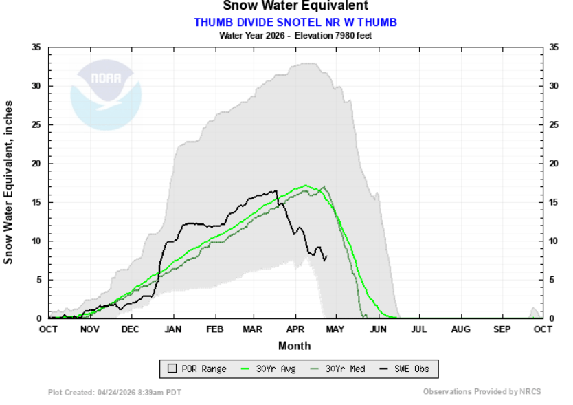
This sensor is on the divide between the Lewis (Snake) River basin and the Yellowstone River basin near Yellowstone Lake. For our purposes, it indicates the snowpack at medium elevations in the upper Yellowstone River basin. Current conditions are indicated by the black line. Notice how it began nosediving in mid-late March, and kept nosediving until mid-April except for that one brief uptick? Since our last update, we’ve had another uptick, plus overall cooler weather that has flattened the curve. Instead of dropping towards that bottom white area, which indicates record lows, we’re now firmly into the gray area which indicates the full range of historical snowpack by year. This gauge is still reporting very low snowpack, and there’s no way we’ll reach that median line (warm weather is forecast beginning in about ten days, which will hasten the drop again), but we’re MUCH better off than we were a couple weeks ago.
Here’s another SNOTEL site, the Two Ocean Plateau SNOTEL at high elevation in the Yellowstone River’s headwaters:
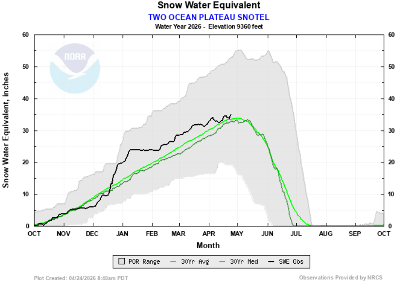
That flatline and little dip in late March was terrifying. Snowpack at this sensor usually peaks around the beginning of May, and this year it dropped noticeably in late March. Even in the record-low year indicated by the confluence of the bottom white area with the gray area, snowpack never noticeably declined until mid-April. Were we in for a precipitous fall starting almost a month ahead of the worst year on record? Thankfully, no. Since then, those blips of snowfall have actually increased snow water content at this sensor to above both mean and median. To be clear, this is just one sensor at very high elevation upstream from Yellowstone Lake where the Yellowstone River is just a creek, but this is also our “last reserve” of snow due to the high elevation, so it’s what will most help flows in late summer.
Other SNOTEL sites post a much grimmer picture, particularly those at lower elevations. Sylvan Lake SNOTEL east of Yellowstone Lake is at 58% of normal. Canyon SNOTEL near Canyon Village is at 50%. Lick Creek southwest of Livingston is at a whopping 8%.
Two sensors west of West Yellowstone that are only about 3mi apart provide a good example of the divide between low elevation and high elevation sensors. Carrot Basin at 9200 feet is at 100% of normal. Beaver Creek at 7820 feet is at 64%.
Overall, we’re still very low on snowpack, but the highest elevations in particular may have enough of a reserve to save our bacon in late July, August, and early September. In particular, we no longer believe full fishing closures are likely anywhere we ever expect to fish in late summer. What a sigh of relief…
The Broader Picture
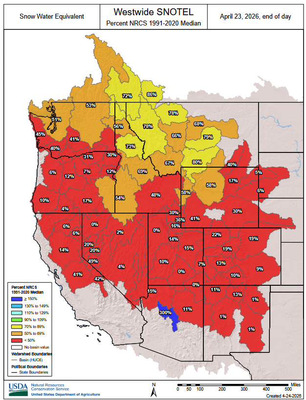
The mixed bag of snowpack at high vs low elevations in our area is exemplified by the following maps, which show snowpack throughout the West, in Montana, and in Wyoming. These maps are updated daily and are available here.
The core of our operations area is that 80% basin in southern Montana, which is the Upper Yellowstone River basin. Portions of our operations area extend into that 67% basin and the 66% to the northwest. As you can see, we’re low in the core of our operations area, but still better off than literally anywhere else in the West except that tiny sliver of 86% east of Glacier National Park in far northwest Montana. Colorado, NM, AZ, UT, NV, CA, and OR are in absolutely dire straits.
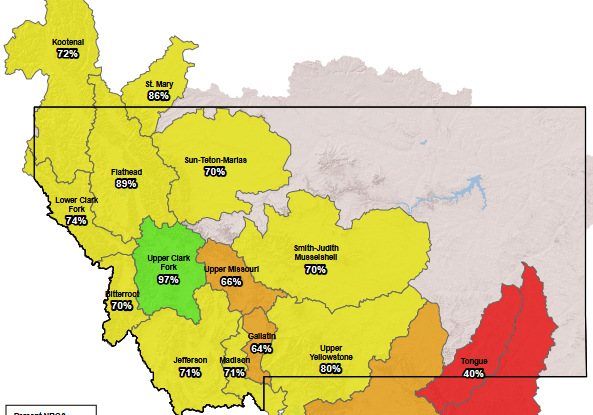
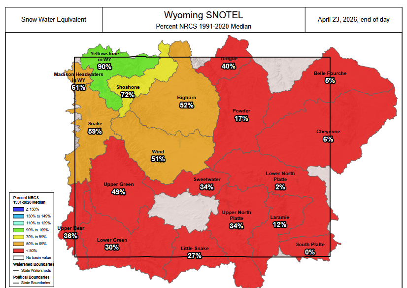
Note the 80% number for the “Upper Yellowstone” basin vs the 90% for the “Yellowstone in Wyoming” basin. The Upper Yellowstone basin is downstream of the Wyoming basin, and factors in its totals. Therefore the Upper Yellowstone in Montana proper is actually below the 80% number. This basically means the tributaries in Montana have much less snowpack than both tributaries and the mainstem in Yellowstone Park. Areas of the mainstem Yellowstone upstream from Livingston depend primarily on Wyoming snowpack for flow. Downstream of Livingston, Montana tributaries gradually become more and more important. Considering irrigation drawdowns, this might be a year when the Yellowstone River has more water in it at Gardiner than it does at Livingston, and more at Livingston than at Big Timber or Columbus. Rivers in the West often get smaller as they flow due to irrigation. The Yellowstone usually isn’t one of them, but this year might be the exception.
So What Does All This Mean?
Runoff has started early, but it is proceeding in fits and starts rather than as one big push. Our next push is likely to begin in the first week of May when the next warmup is forecast. In contrast to several earlier blog posts, we do now expect a “real” runoff, though it will be more limited both in duration and in magnitude than usual.
We are still low on snowpack, especially at lower elevations. Pretty much any basin that drains moderate-elevation mountains is very low. The Madison Basin in YNP is only at 61% of normal, for example. This low snowpack WILL mean warm, low water in late summer. How low and warm will depend on summer heat and moisture. It still seems likely we’ll see some to many 2:00PM fishing closures, particularly in the first three weeks of August, but we now no longer expect full closures in places where the fishing is ever good in this timeframe. Even the 2:00PM closures may be limited in scope if we have a relatively cool summer, or at least one with some breaks.
Fires may still be a problem, particularly at lower elevations (where there have already been many grass fires this spring), and smoke may be a BIG problem from fires burning elsewhere in the West, which are much drier than we are.
Here’s a big one: The core of our operations area will have the best water conditions of any major basin in the entire West. They still aren’t going to be ideal, particularly in August, but we now expect them to be at least tolerable. That’s a big change from a few weeks ago.
When Should I Fish?
Late June and the first three weeks of July are likely to offer the best fishing on most fisheries in our operations area, certainly the month of July at the very latest. Late July might or might not be tough, depending on temperatures. August and early September are likely to be difficult, with some to many 2:00PM fishing closures. Even if we miss the closures, the fish are likely to be spooky until the fall rains hit in mid-late September.
Best & Worse Periods by Fishery
Rivers are given in increasing distance from Livingston, while “classes” of waters (such as mountain creeks) are given at the end.
- Yellowstone River in Montana: Best from mid-June through about July 20. Hoot owl closures are possible but no longer certain between July 20 and early September.
- Boulder River: Best in June. Probably too low to float by July 4. Likely hoot owl closures below Natural Bridge from July 20 through Labor Day.
- Gardner River: Best in June below Boiling River, late June and July above. Too warm below Boiling River no later than July 10. Likely hoot owls below Osprey Falls from late July through Labor Day.
- Lower Madison River: Best between now and early June. Likely hoot owls from late June through late September. Likely complete fishing closures from early July through early September.
- Gallatin River in MT: Best from mid-June through July. Likely hoot-owl closures below Gallatin Gateway between July 20 and Labor Day. The upper sections may avoid hoot owl closures. Likely complete closures between Four Corners and the mouth of the East Gallatin in August.
- Yellowstone River Canyons in YNP: Best from mid-June through July. Hoot owls are possible from July 20 through Labor Day.
- Stillwater River: Best in late June and July. Possible hoot owls from July 20 through Labor Day. Too low to float in a full-size raft by mid-August.
- Lamar River, Slough Creek, Soda Butte Creek: Best late June through late July. Hoot owls possible July 20 through Labor Day.
- Gibbon River: Below Norris Hot Springs best in mid-late May and too warm by June 15. Above best in June. Likely hoot owls from late June or early July through Labor Day and complete closures from early July through Labor Day.
- Upper Madison River (MT): Best in June and early July. Potential hoot owls from July 20 through late August, but on this river they will probably be very limited both in duration and scope. The stretch from the Ennis Bridge to Ennis Lake is the most likely stretch to be closed.
- Firehole River and Madison River in YNP: Best in May. Almost certainly too warm to fish ethically with the onset of the first hot spell in early June. Complete closures are likely from late June through Labor Day and perhaps through September.
- Jefferson River: In all honesty, this river is going to suffer so much this season (as will the lower reaches of its sources the Beaverhead, Big Hole, and Ruby), that we do not recommend fishing it at all this season. We expect full closures on the Jeff, the entire Big Hole, and the lower Ruby and Beaverhead no later than July 20 this season, likely extending through September.
- Missouri River (Tailwaters): Best in late May and June. Hoot-owls are possible but unlikely between July 20 and Labor Day, but these areas will almost certainly be extraordinarily weedy from August through early October. Headwaters reaches (carp water) will probably not see closures.
- Private Spring Creeks: Limited impacts due to the drought, since these are entirely spring-fed. Best fishing (as always) from late June through July.
- Mountain Creeks in Montana: Best in July. Probably will not see late summer closures, but may be so low that they are unethical to fish, particularly in late August and September.
- Prairie Creeks & Small Rivers in MT: Best in June. Likely to get too warm to fish ethically in early July (basically with the first real hot spell). Those that see much pressure, such as the Shields, Smith, and East Gallatin, will see hoot owls for sure by mid-July and may see complete closures in the same timeframe, with all closures lasting into mid-September.
- Mountain Creeks in Yellowstone Park: Best in July. Those at lower elevations like Hellroaring and lower Lava Creek may see hoot owls in August.
- Creeks Draining Yellowstone’s Central Plateau: These meadow-type, small streams will be best in June. Hoot-owls now seem unlikely, but they’ll be so low by July 20 you won’t want to fish them after that, anyway.
- Private Ranch Lakes: Best from now through mid-June. Almost certainly too warm to fish well/ethically between late June and late September, though they do not actually see any closures since they’re private. It seems likely that many will see fish kills due to warm water this year.
- Low-Elevation Reservoirs: Best from now through late May. Too warm and weedy by mid-June, though unlikely to see closures.
- High-Elevation Drive-Up Lakes and Reservoirs (Hebgen, Yellowstone Lake): Those in Montana are best from now through June. Likely too warm to fish well most days in late summer, though closures are unlikely. Those in YNP open the Saturday of Memorial Day Weekend and should be ice-free and accessible by then. All will fish best in June and be weedy and not so good by mid-July, though 2:00 closures are much less likely on lakes in YNP than on rivers.
- Hike-In Lakes: Those in Montana (Beartooths) will be best in late June and July. August might see tough fishing, though closures are unlikely. Those in YNP will be best in June and many/most will be very tough between mid-July and mid-September, though closures are unlikely.