Snowpack Update for Feb 22 2023
Posted on February 22nd, 2023 in Newsletters, Season Forecasts, Weather & Water Conditions
After a wet past week and bitter cold weather (below zero in Livingston, probably -20 in YNP) snowpack has risen back to over 100% of normal for the date. This is great news. We had been trending steadily downward for the past 6–8 weeks in comparison to normal after a very cold and wet autumn.
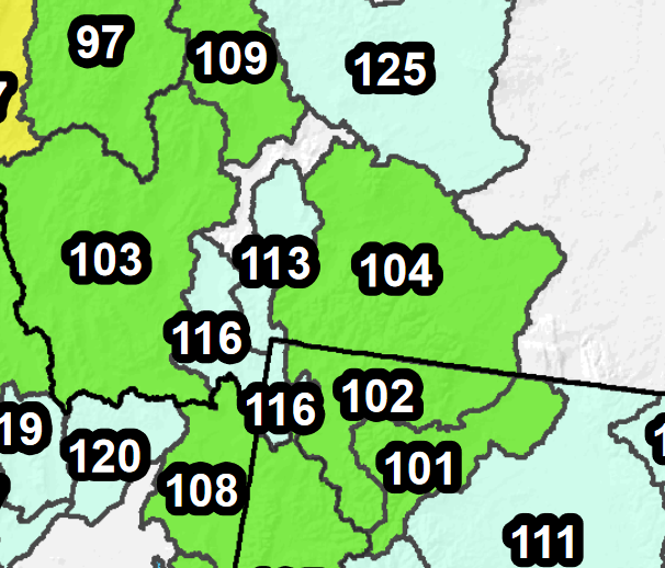
We like snowpack to run 100–110% in our main basins (Yellowstone River in Montana and YNP, currently 102% and 104% of normal on the graphic) as of mid-May. This ensures enough water to keep the Yellowstone and its main tributaries like the Lamar, Gardner, Boulder, and Stillwater running high and cold all summer, which keeps the trout happy, but also for them to drop into fishable level and clarity at the normal time in the last week of June or first week of July, which keeps fishermen and guides happy. As of right now, we’re right on track for good conditions this summer.

Northwest Wyoming and south-central Montana snowpack numbers for February 22, 2023.
A couple of positive oddities in this map are worth noting.
First off is that the Yellowstone outside YNP is showing higher snowpack than inside the park. Again, 104%. This number actually factors in the snowpack in the upper Yellowstone Basin too, since it all flows downhill. All things considered, the mountains feeding the creeks between Gardiner and Livingston, plus the Shields, Boulder, and Stillwater Basins further east, actually have stronger snowpack than Yellowstone does. Since these basins all suffer from irrigation drawdowns and thus struggle to stay cold all summer, this solid snowpack could really help keep water temps on the Yellowstone east of Livingston cold all summer (no early-out at 2:00PM) and also keep the Boulder and Stillwater floatable will full-size rafts until later in the season. Both these rivers are floatable an extra month in our new ultralight raft (photo courtesy Smithfly) anyway, but the big raft is more roomy and comfortable.
The second oddity is even more exciting. The Madison-Gallatin basin in YNP is at 116% of normal. Usually this basin lags behind the basins further north, primarily because the mountains at the headwaters of the Madison basin in YNP feeding the Firehole and Gibbon Rivers are lower elevation than the ranges elsewhere, meaning the snow tends to skip overhead. The West Yellowstone SNOTEL sensor at relatively low elevation reports a whopping 131% of normal snowpack.
What’s all this mean for the Madison, Firehole, Gibbon, and Gallatin? Well, for right now it means nothing. A big warmup in May and June could melt all that snow in a hurry. That said, if current trends continue, the Firehole, Madison, and Gibbon will have much more cold water entering the system than usual, until later in the summer. Since warm water is the problem in these basins after about June 20, this could lead to a longer late spring fishing season on the Firehole, Gibbon, and Madison in YNP, possibly well into July when we’re usually done fishing this area until late September around June 20–25. Great news for Firehole fans!
If the above numbers hold, we could actually have a fishable Yellowstone, Boulder, and Gardner River at the same time we still have a fishable Firehole and Gibbon. Usually there’s a shaky week in late June or the first week of July when none of the above are prime, and I honestly can’t remember a year when both drainages are prime. Let’s hope this year is the outlier!
Our next snowpack update will drop sometime in the first half of March, especially if a big warmup or a giant storm substantially changes the above numbers. In the meantime, follow the westwide snowpack numbers at this link, which is updated daily. The drainages important to our operations are all near the junction of Wyoming and Montana.