2021 Winter Snowpack Update and Summer Fishing Forecast
Posted on March 6th, 2021
Intro
Winter is now 3/4 over here in Yellowstone Country, which means we have a fair idea of what summer streamflows are going to look like. If you aren’t familiar with the Western water year, we get most of our summer streamflow from snowpack. High snowpack that melts late and we have high water. Low snowpack that melts early, low water.
All in all, we like snowpack to sit around 110% of normal when it starts melting in late April. This gives us a slightly late start on summer waters like the Yellowstone, Lamar, Boulder, and Stillwater, but also gives us a cushion of higher, colder water if late summer is hot and dry.
Lower snowpack than this makes it more likely we’ll have low, warm water in late summer, with the potential for closures or at least tough late-afternoon fishing in early August. Higher snowpack than 110% means a very late start on summer rivers, though usually excellent fishing from late July onward.
The Winter So Far
Winter started in early October, with heavy snowfall and cold weather. Then the script flipped from November through January. During this period, we had far warmer and drier conditions than normal, which led to extremely low snowpack and the prospects for a dangerous drought. If you believe it, we had heavier snowfalls and colder temperatures here in Livingston in October than in January.
The script flipped again at the beginning of February. All of February was cold and wet in the region, which dramatically increased snowpack throughout the region and moved us largely out of the danger zone (for now). The first few days of March have been very warm and dry, though it is supposed to cool off and get wet again over the next week.
Current Conditions
Here’s a map covering “west-wide” snowpack. Green and pale blue are good. Yellow and especially orange and red are bad. The northwestern corner of Wyoming and southern Montana are the drainage basins that impact our waters. As you can see, southwest Montana and Yellowstone are in pretty good shape compared to many areas in the West, especially points south of us.
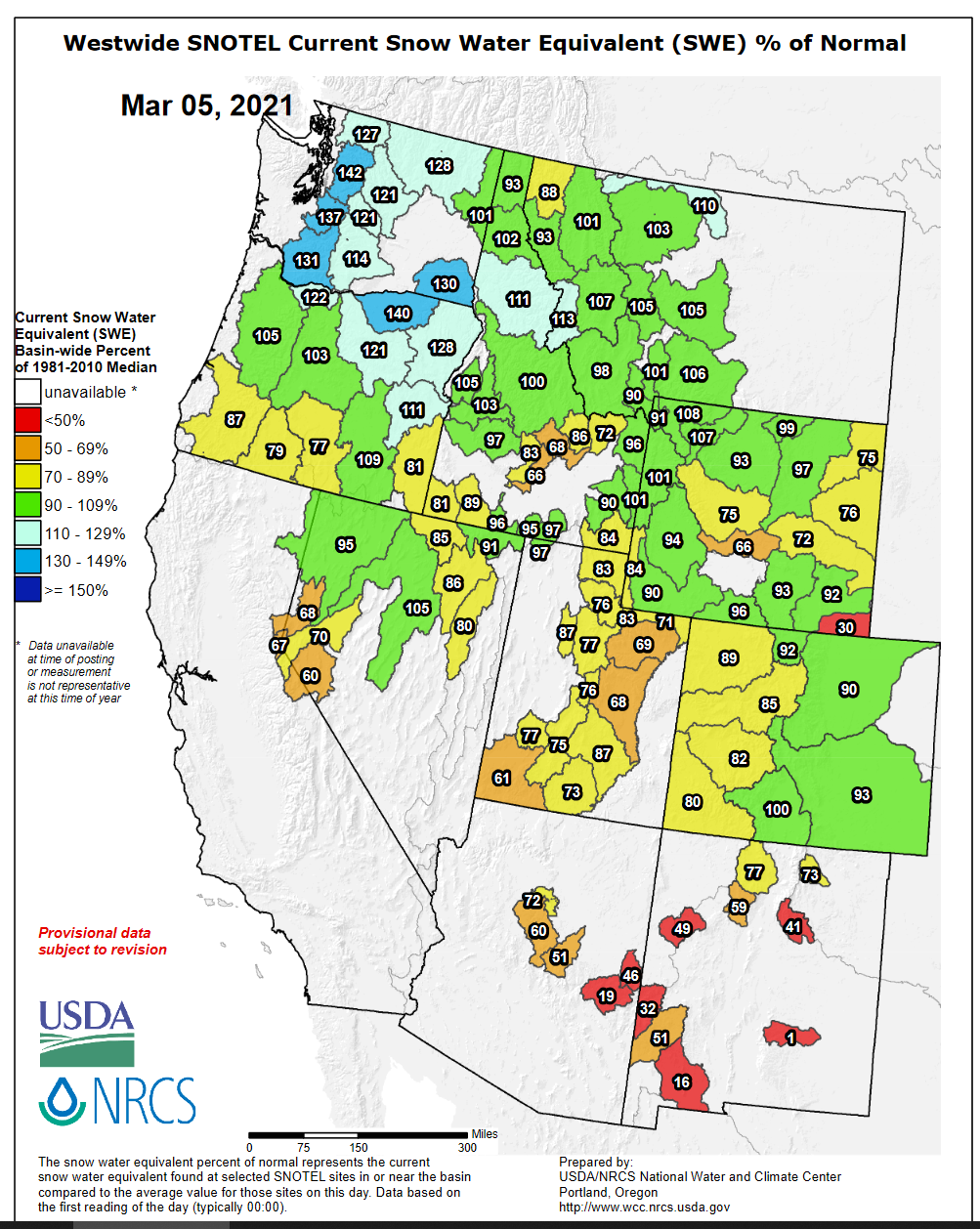
This graph updated daily can be accessed at this link.
Narrowing our focus a bit, here’s Montana, with little extensions showing basins in NW Wyoming that impact our operations. Our approximate operations area is outlined in the medium red line.
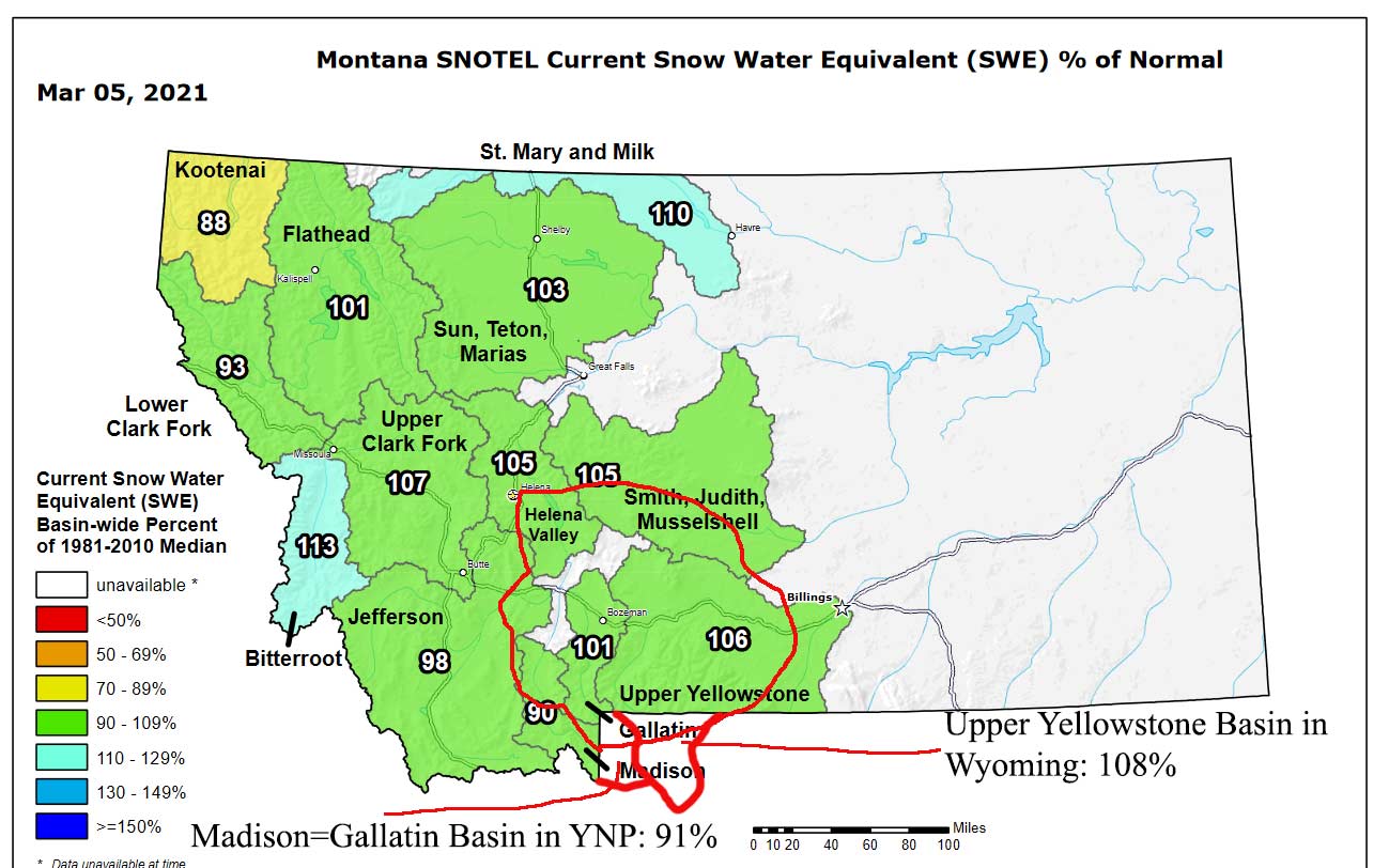
Access versions of this graph updated most days at this link.
To interpret the above numbers, snowpack within our operations area ranges from 90% to 108% of normal. The most important basins, the Upper Yellowstone in Wyoming and upper Yellowstone in Montana, are at 108% and 106%, respectively. So far so good. We wouldn’t mind if things were a bit higher, but we were 20 points lower six weeks ago.
We are definitely not out of the woods yet, though. We’ve still got about six weeks to build or lose snowpack before the normal spring melt begins.
Outlooks for the Next Three Months
March, April, and May weather will govern whether the decent numbers above translate to summer. This crystal ball is unclear. This graph is updated on the third Thursday of every month. It predicts an equal chance of above and below normal temps and above and below normal precip for March through May. So no help there.
Shorter-term outlooks for March are more pessimistic and predict below normal precip. Going off the short-term weather forecast and these outlooks, that’s honestly what I expect, too.
Summer Streamflow Conditions Outlook
Taking all of the above into account, here’s what I believe we’re looking at as of right now:
- Below normal to near-normal snowpack and likely summer water conditions: February is the only reason we’ll even be near-normal, but the long-range outlooks suggest things will stay flat or decline slightly through the spring until the real melt hits.
- Warm water temps in the last week of July and first half of August, but no closures of note: While we don’t have enough snowpack to guarantee cool water and frisky fish through summer, we should have enough to prevent any drought-related closures in all of the important summer basins, basically meaning all of the Yellowstone drainage. The lower Jefferson, lower Madison, and some other dribs and drabs are likely to have 2:00PM closures in late July and August (the Madison always does), but these aren’t places we fish at that time, anyway.
Most specific predictions will have to wait another six to eight weeks, when we know for sure what our snowpack looks like and whether or not the heavy melt has started drastically early.
The one thing I do feel pretty confident in stating is that the Firehole River is going to get too warm by June 20-25 this year. With only a 91% snowpack in its basin at the moment, it is very unlikely it will climb to average. Basically, as soon as it really gets hot and sunny in mid-late June, that’ll be it for the Firehole. If you’re a Firehole fanatic, I suggest coming before June 20. The YNP season opener this year is May 29.
Sources for Streamflow Data
Posted on March 4th, 2021
Virtually all fly fishing guides and outfitters in Montana watch streamflow data and streamflow forecasts like hawks, especially during runoff season (that is to say: right now) and when summer thunderstorms are rolling around. This is no different than farmers watching the weather forecasts. Here are the important sites to allow YOU to check streamflows, both right now and expected flows for the days ahead.
Montana Streamflow Data: This site returns data from all USGS gauging stations in Montana. The site is organized by river drainage, then from upstream gauging stations to downstream stations. In my area, the Yellowstone Basin graphs from the Lamar River in Yellowstone Park down to the graph at Springdale are the graphs I use most often, with the Stillwater graph secondary. By far the most important graphs for general streamflow are the Corwin Springs and Livingston graphs on the Yellowstone, while the Lamar and Gardner graphs are important for telling me about sudden rises in water level (which are almost always accompanied by mud) due to storms.
Advanced Hydrologic Prediction Service – Billings: Here’s the streamflow prediction site for eastern Montana. This site shows flow graphs noted in the previous link, but also shows predicted flows for the next few days for most gauging stations. The basic graph pictured below is most useful during the spring runoff season when we are trying to plan for future trips based on weather forecast. If you’re looking at a big predicted bump coming up, it’s best to get fishing beforehand, because that bump means mud.

This site also includes an option to view “Probability Information.” This is a longer-range forecast of predicted flows, but it isn’t updated very often and I often find it inaccurate. Here’s a sample graph of probability information:

Select the above graph by clicking the dropdown menu off the lower right corner of the graph, then selecting “Flow – Weekly Chance of Exceeding Levels.” This is most useful to anglers, as flow rather than gauge height determines fishability. Too much water and things are too rough, and probably muddy to boot.
May-Midge Cripple Fly Tying Video
Posted on March 4th, 2021
We tied the May-Midge as something of an experiment prior to the 2019, intending it to combine attributes of midge patterns like the Griffith’s Gnat while maintaining the overall silhouette of tiny, sparse mayflies. Our goal with this fly was to come up with something that would fool the spooky, lazily-rising fish we often see in the morning in flat water in late summer and early fall. These fish seldom eat any one thing in particular, but are feeding on a mixture of midges and the duns of three or four species of mayflies, as well as the occasional odd ant, mayfly spinner, and other “schmutz.” The May-Midge proved extremely effective in this role this season, particularly in the Lamar Drainage, where it turned out several very large fish on lower Slough Creek that were turned off by larger and/or more heavily-dressed flies.
Note: This fly is intended for use in slow water, particularly big eddy lines or places with many complicated micro-currents. It should not be used in choppy water, as it won’t float well in chop.
Recipe
Hook: #16-22 1x short, 1x fine emerger hook.
Thread #1 and Abdomen: Claret Veevus Body Quill (I called it wine in the video).
Tail/Shuck: Gray Sparkle Emerger Yarn or similar.
Thread #2: 8/0 or 10/0 wine.
Wing: White Widow’s Web or similar synthetic yarn.
Hackle: Grizzly saddle, tied sparse.
Thorax: UV Brown Ice Dub.
Other Colors: Light olive, black, copper, gray (use alternate abdomen material on gray, as there is no gray Body Quill). Change threads and dubbing to match desired fly color. Tail, wing, and hackle do not change.